Log in
All resources
Create a design
4,384 Free Artworks of Title Pages Of Maps
maps from the earth and its inhabitants, vol. iv
maps from the earth and its inhabitants, vol. xvii
géographie générale; physique, politique et économique (1876)
arnold's geographical handbook (1899)
maps from the earth and its inhabitants, vol. xv
maps from the earth and its inhabitants, vol. xii
maps from the earth and its inhabitants, vol. xiii
mississippi delta
maps from the earth and its inhabitants, vol. ix
maps from the earth and its inhabitants, vol. viii
maps from the earth and its inhabitants, vol. ix
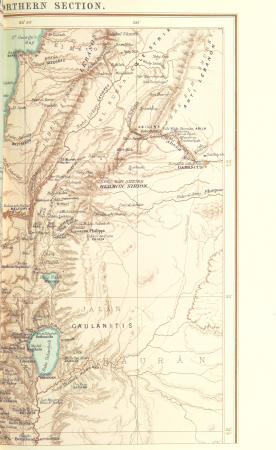
1870s maps of jerusalem
maps from the earth and its inhabitants, vol. xi
1870s maps of tunisia
maps from the earth and its inhabitants, vol. viii
1870s maps of india
the comprehensive history of england (1876)
english-language maps showing history
herman diederik joan van schevichaven
revolt of the batavi
john rocque's 1746 map of london
old and new london (book)
geographia universalis (1545) in the british museum
german renaissance,northern renaissance
too late for gordon and khartoum (1887) by macdonald
old maps of the nile
wolffgang hartmann
philipp clüver
redeeming the republic (1890)
1890s maps showing history
the cruise of the marchesa (1889)
1880s maps of the philippines
maps from the earth and its inhabitants, vol. iv
topographic maps of scotland
book covers from the british library mechanical curator collection
books about africa
the cruise of the marchesa (1889)
19th-century maps of borneo
1876 maps of the united states
old maps of new england
corona and coronet (1898)
1898 maps of the world
1700s maps of germany
battle of blenheim
women of the world from the british library mechanical curator collection
siberia in the 19th century
a treatise on ore deposits (1896)
1890s maps of saxony
french-language maps of south africa
1876 maps of africa
1876 maps of north america
1876 maps of the caribbean
nouveau cours d'instruction primaire de géographie (1886)
1886 maps of france
with the armies of the balkans and at gallipoli (1880)
battle of gallipoli
maps from the earth and its inhabitants, vol. ix
old maps of the holy land
arnold's geographical handbook (1899)
1899 maps of the caribbean
dr. wilh. junker's reisen in afrika 1875-1886
1880s maps of sudan
maps of assen
paterswolde
atlas sive cosmographicae (gerardus mercator, 1623)
maps of corsica by gerardus mercator
arnold's geographical handbook (1899)
1899 maps of india
book covers from the british library mechanical curator collection
adolphe giraldon
maps from the earth and its inhabitants, vol. xvii
maps of louisville, kentucky
maps from the earth and its inhabitants, vol. xv
exploration of the arctic
maps from the earth and its inhabitants, vol. vi
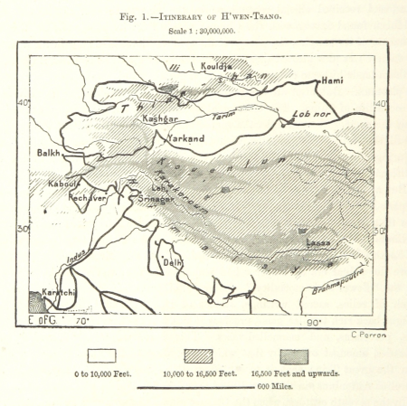
charles eugène perron
maps from the earth and its inhabitants, vol. iv
boston, england
maps from the earth and its inhabitants, vol. viii
buddhist pilgrimage sites in india
the comprehensive history of england (1876)
english-language maps showing history
maps from the earth and its inhabitants, vol. vi
latin-language maps
maps of rivers of senegal
bafing river
maps from the earth and its inhabitants, vol. ix
maps of telegraph lines
old maps of south africa
maps of the great trek
maps from the earth and its inhabitants, vol. iv
maps of portland, england
maps from the earth and its inhabitants, vol. xv
maps indicating exploration
maps from the earth and its inhabitants, vol. x
19th-century maps of egypt
maps by willem and johannes blaeu
history of gennep
maps from the earth and its inhabitants, vol. xvii
anton francesco lucini
maps from the earth and its inhabitants, vol. vii
maps of xuanzang's travels
maps from the earth and its inhabitants, vol. iv
maps of loch fyne
maps from the earth and its inhabitants, vol. vii
maps of the yellow river
maps from the earth and its inhabitants, vol. xiii
ethnographic maps of africa
maps from the earth and its inhabitants, vol. iv
mouth of tay
maps from the earth and its inhabitants, vol. xi
maps indicating exploration
maps from the earth and its inhabitants, vol. iv
maps of kirkwall
maps from the earth and its inhabitants, vol. xii
maps of icebergs
maps of the western cape
breede river
maps of pangong tso
old maps of ladakh
giovanni battista rossi
1890s maps of yemen
maps from the earth and its inhabitants, vol. viii
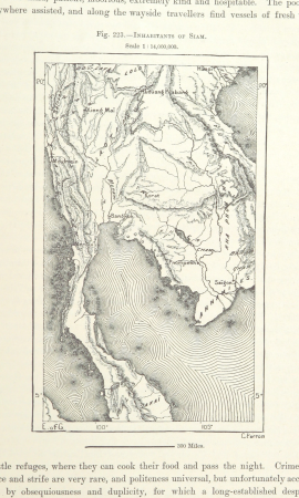
demographic maps of thailand
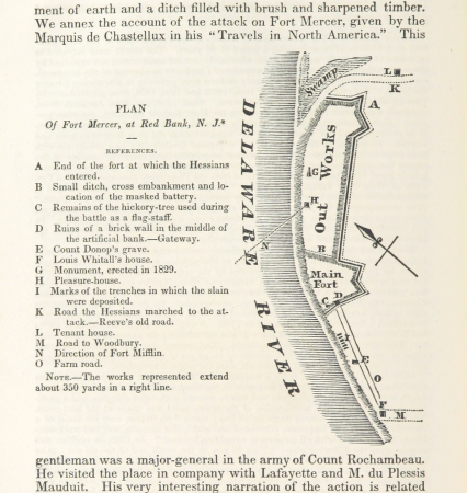
19th-century maps of new jersey
maps of the delaware river
nouvelle géographie universelle, vol. viii
1876 maps of india
arnold's geographical handbook (1899)
global maps of climate zones
maps in the library of congress
1708 maps
1890s maps of the atlantic ocean
cavite e santiago (1898)
arnold's geographical handbook (1899)
maps of ocean currents
the cruise of the marchesa (1889)
19th-century maps of new guinea
great explorers of africa (1894)
ghosts & ghoulish scenes
maps from the earth and its inhabitants, vol. iv
maps of glenmore
cavite e santiago (1898)
1898 maps of cuba
cavite e santiago (1898)
1898 maps of cuba
maps from the earth and its inhabitants, vol. iv
topographic maps of ireland
maps from the earth and its inhabitants, vol. xv
19th-century maps of british columbia
ghosts & ghoulish scenes
maps from the earth and its inhabitants, vol. iv
topographic maps of the united kingdom
old maps of la gomera
1878 maps of spain
maps from the earth and its inhabitants, vol. xii
19th-century maps of senegal
maps from the earth and its inhabitants, vol. iv
old maps of the lake district
maps from the earth and its inhabitants, vol. xiii
maps of weather and climate of south africa
maps from the earth and its inhabitants, vol. xv
19th-century maps of british columbia
maps from the earth and its inhabitants, vol. xiv
1870s maps of new zealand
maps from the earth and its inhabitants, vol. iv
old maps of the lake district
geographia universalis (1545) in the british museum
german renaissance,northern renaissance
richard wane
port erin
geographia universalis (1545) in the british museum
german renaissance,northern renaissance
siberia and the exile system (1891)
19th-century maps of siberia
siberia and the exile system (1891)
19th-century maps of siberia
our arctic province, alaska and the seal islands (1886)
old maps of alaska
maps from the earth and its inhabitants, vol. xvii
mississippi delta
maps from the earth and its inhabitants, vol. xvii
mississippi delta
maps from the earth and its inhabitants, vol. xvii
mississippi delta
maps from the earth and its inhabitants, vol. xvii
lake champlain
maps from the earth and its inhabitants, vol. iv
lake area comparison diagrams
maps from the earth and its inhabitants, vol. xvii
mississippi delta
maps from the earth and its inhabitants, vol. xvii
lake champlain
géographie générale; physique, politique et économique (1876)
19th-century maps of bretagne
géographie générale; physique, politique et économique (1876)
old maps of the strait of gibraltar
with the armies of the balkans and at gallipoli (1880)
maps of the military history of bulgaria
old maps of dublin
dublin bay
old hemisphere world maps (partner files)
arnold's geographical handbook (1899)
a school geography (1898) by bird
old maps of french polynesia
den danske hærs historie til nutiden og den norske hærs historie indtil 1814
maps of battles of sweden
in the volcanic eifel. a holiday ramble (1896)
old maps of eifel
201 - 300 of 4,384
Next page
/ 44